When Mobiltech, a leader in data collection instruments and urban digital twins, set out to build a highly precise logging system for autonomous driving, it faced a formidable challenge. The project required the collection and processing of vast amounts of high-quality ground truth data — the critical foundation for validating advanced driver assistance systems (ADAS) and self-driving algorithms. Mobiltech needed a solution that could deliver continuous, centimeter-level accuracy even in challenging environments such as urban canyons and highways, while ensuring precise synchronization of a multi-sensor system.
The company turned to Trimble®, leveraging the Applanix POS LV® series and POSPac MMS® solutions as the core of its ground truth system. Mobiltech has been using Trimble’s technology since 2018, later expanding its portfolio to include the Applanix POS APX® series and POSPac UAV® solution. This long-term partnership points to the reliability and technical excellence of Trimble’s products.
A representative project with Hyundai demonstrated the power of this collaboration. Mobiltech used the POS LV125 and POSPac MMS to create high-quality datasets that precisely captured vehicle motion and environmental data. A key technical hurdle was maintaining a centimeter-level precision trajectory in a dynamic environment while synchronizing outputs from more than 10 cameras, multi-channel LiDAR and GNSS and inertial navigation system (INS) sensors. By utilizing the POS LV125’s Pulse Per Second (PPS ) signals and National Marine Electronics Association (NMEA) messages as reference, Mobiltech developed a custom synchronization board, creating a unified master clock. This minimized temporal discrepancies across all sensors, significantly enhancing data consistency and system reliability.
A critical benefit was the automation of the data processing pipeline. The auto-batch feature of POSPac MMS enabled a fully automated workflow, from data acquisition in the field to post-processing in the office. This streamlined process resulted in significant gains in operational efficiency and productivity.
“The automation features, in particular, significantly reduced our processing time and increased our productivity,” said Mobiltech CEO Jason Kim. “Trimble’s technical excellence, especially its industry-leading GNSS/INS accuracy and stability, has been instrumental in our projects.”
The results speak for themselves. The collaboration has allowed Mobiltech to achieve precise positioning and continuous trajectory generation, overcoming issues commonly associated with GNSS-challenged environments. The system’s post-processing capabilities and the ability to integrate seamlessly with other sensors have been paramount.
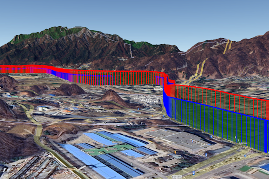
Red : LV real-time data / blue : LV post-processed data
Beyond the technology, the relationship between Mobiltech and Trimble has been a key factor in their success. Kim specifically noted the "prompt and professional" technical support, which has been crucial for addressing complex issues. This partnership extends beyond a simple customer-vendor relationship, helping Mobiltech achieve meaningful outcomes in the rapidly evolving field of autonomous driving technology, said Kim. With Trimble's solutions, Mobiltech is well-positioned to continue innovating and delivering the precise data that fuels the next generation of smart vehicles.


